The author rides a 2008 Victory Vision Tour

Saturday, November 28, 2009

Portland, Oregon to Detroit Lake loop Part 4: Home stretch

scenic-motorcycle-routemotorcycle riding

Looking for a day-long scenic ride out of Portland, Oregon? This one winds along whitewater, meanders through forests, follows along lakes and passes through small towns and farms. Part Four: The home stretch...

Turn north on the Cascade Highway into the town of Sublimity. The Cascade Highway will take you all the way back to Oregon City. This northerly leg of the motorcycling loop wanders through farms, wineries, and beautiful rural areas.

The town of Silverton is picturesque and worth a stop for coffee or grub. Lots of art galleries and the nearby Silver Falls State Park draw visitors to the town. Leave Silverton on OR-213, and enjoy some excellent motorcycling to Oregon City, your return to urban reality.

See Part 1 of the Detroit Lake loop series for a map of this scenic motorcycle ride.

Read more!

Saturday, November 21, 2009

Portland, Oregon to Detroit Lake loop Part 3

scenic-motorcycle-routescenic motorcycle ride

Looking for a day-long scenic ride out of Portland, Oregon? This one winds along whitewater, meanders through forests, follows along lakes and passes through small towns and farms. Part Three...

After motorcycling through the Willamette National Forest, this scenic route meets OR-22 at the community of Detroit. Detroit is a favorite recreational area with marinas, campgrounds, and of course the spectacular lake.

RIDER ALERT-GRUB STOP: There is a great little restaurant in Detroit tailored for motorcyclists. Inside is a room with tons of motorcycle history and memorabilia displayed. Look for the place with the motorcycle on the roof.

From here, take OR-22 west as it follows the lake shore. The dam that creates the lake announces the North Santiam River, and the road shadows the river as it flows towards the Pacific.

See Part 1 for a map of this scenic motorcycle ride and check back later for Part 4 of the Detroit Lake loop series.

Read more!

Sunday, November 8, 2009

Portland, Oregon to Detroit Lake loop Part 2

scenic-motorcycle-route
Looking for a day-long scenic ride out of Portland, Oregon? This one winds along whitewater, meanders through forests, follows along lakes and passes through small towns and farms. Part Two... With Estacada behind you, OR-224 climbs east along the Clackamas River into the Northern Cascades.

A popular white-water rafting spot, the river roils and there are numerous places to pull over and watch the crazy people attempt to stay afloat. OR-224 becomes National Forest Road 46 about 60 miles from Oregon City and campgrounds appear every few miles.

RIDER ALERT-ROUGH ROAD: As you near Detroit, the last 20 miles of pavement has numerous ashpalt patches that make for a potentially rough ride. Slow down to minimize the bumps. Also be advised that on sunny days the sun/shade pattern coming through the trees makes it very difficult to pick out these road hazards.

See Part 1 for a map of this scenic motorcycle ride and check back later for Part 3 of the Detroit Lake loop series.

Read more!

Portland, Oregon to Detroit Lake loop Part 1

scenic-motorcycle-route
Looking for a day-long scenic ride out of Portland, Oregon? This one winds along whitewater, meanders through forests, follows along lakes and passes through small towns and farms.

Take OR-211/224 E out of Oregon City. This scenic route follows the Clackamas River past tree farms and small communities to Estacada, where OR-211 and OR-224 split.

RIDER ALERT-GRUB STOP: A cool place for coffee or lunch is the Cazadero Inn. Good food and huge windows look out over the river.

Once back on the road, be sure to continue east on OR-224 where it splits from OR-211. Check back later for Part 2 of this story.

View Larger Map

Read more!

Saturday, August 15, 2009

Changes to the Motodometer motorcycle blog

scenic-motorcycle-route
A small change is coming to the Motodometer motorcycle blog. Notice the little odometer graphic on each post? The numbers are about to change! I am going back, and changing the little odometer graphic sitting at the top of each post. Before it was the mileage on my bike's odometer when I did the motorcycle ride. Now it will be changed to show the approximate mileage of the actual motorcycle ride described in the post. The number will be total miles for the entire motorcycle trip, even if the post only covers a portion of that trip. Hopefully this will help in planning day trips by quickly identifying how long a motorcycle ride is without having to read through the whole post.

Read more!

Friday, June 26, 2009

Part 6 | Motorcycle Portland, Oregon to Yellowstone

scenic-motorcycle-routescenic-motorcycle-route

Anaconda to West Yellowstone: After a long winter of limited motorcycle riding, a ride from Portland, Oregon over the Continental Divide to Yellowstone might be just what the doctor ordered. This is the sixth part in the Portland, Oregon to Yellowstone series.

After another 50 miles on I-90, we were ready for more off-interstate motorcycling. We cut south on MT-41 and US 287, and cruised through numerous picturesque small towns on the road to Virginia City. You definitely feel the mountains coming and we saw rain showers holding menacingly over the mountain passes. Virginia City is an old mining town set up with an eye for tourists. But turning south on US 287 in Ennis, the famous fishing of the Madison River became the focus. The highway follows the Madison up, up , and up to Quake Lake, formed when a 1959 earthquake caused a massive slide blocking the outflow of Hebgen Lake.

Just a few miles past Hebgen Lake is the town of West Yellowstone, one gateway into Yellowstone National Park.

Read more!

Monday, June 22, 2009

Part 5 | Motorcycle Portland, Oregon to Yellowstone

scenic-motorcycle-route

Missoula to Anaconda: After a long winter of limited motorcycle riding, a ride from Portland, Oregon over the Continental Divide to Yellowstone might be just what the doctor ordered. This is the fifth part in the Portland, Oregon to Yellowstone series.

Zooming along I-90 at Montana freeway speeds is fun for awhile, but MT-1 is a far more pleasant motorcycle ride. After running about 50 miles east on Interstate 90, we turned right onto the scenic MT-1, through the Deerlodge National Forest and alongside Georgetown Lake. Phillipsburg is a friendly town catering to the nearby Discovery ski area. MT-1 eventually runs through the mining town of Anaconda and the landmark stack (the Washington Monument would fit inside) standing sentry over the town.
Read more!

Thursday, June 18, 2009

Part 4 | Motorcycle Portland, Oregon to Yellowstone

scenic-motorcycle-routescenic-motorcycle-route

Lewiston to Missoula: After a long winter of limited motorcycle riding, a ride from Portland, Oregon, over the Continental Divide to Yellowstone might be just what the doctor ordered. This is the fourth part in the Portland, Oregon to Yellowstone series.

U.S. Highway 12 is a beautiful and recently completed (1960s) stretch of highway connecting Lewiston, Idaho with Missoula, Montana. It follows several rivers, climbs through Lolo Pass, and finally drops down into Montana. This road keeps you interested with white-water rafters, zooming around curves through the forest, and dodging rain showers as you wind through the Bitterroot mountain range. Click here for more information on motorcycling this scenic route.
.

Read more!

Monday, June 15, 2009

Part 3 | Motorcycle Portland, Oregon to Yellowstone

scenic-motorcycle-route

scenic-motorcycle-route

Pendleton to Lewiston: After a long winter of limited motorcycle riding, a ride from Portland, Oregon, over the Continental Divide to Yellowstone might be just what the doctor ordered. This is the third part in the Portland, Oregon to Yellowstone series.

Leaving Pendleton, Oregon, the Yellowstone motorcycle trip turns north and crosses into Washington at Walla Walla. If you have a little time, stop and enjoy one of the numerous vineyards and small wineries in the area.

Continuing north on WA 12, the highway skirts the western edge of mountains through small but friendly towns like Waitsburg, Dayton, and Pomeroy. The road itself is curvy but high-speed, and your motorcycle can easily cruise around 55mph while taking in the farms and rolling hills. About 25 miles before Lewiston, the road peaks in elevation at Alpowa Summit, then descends rapidly until it meets up with and follows along the Snake River. Cross over the border into Idaho, and your motorcycle and you can take a break in Lewiston.

Read more!

Saturday, June 13, 2009

Part 2 | Motorcycle Portland, Oregon to Yellowstone

scenic-motorcycle-routescenic-motorcycle-route

Portland to Pendleton: After a long winter of limited motorcycle riding, a ride from Portland, Oregon over the Continental Divide to Yellowstone might be just what the doctor ordered. This is the second part in the Portland, Oregon to Yellowstone series.

scenic-motorcycle-routeThe first 60 miles of the Yellowstone trek as you motorcycle east out of Portland, Oregon is the lush, forested, often cloudy and misty Columbia Gorge National Scenic Area. Rivers, waterfalls, and green things line the roads on either side of the Columbia River. The climate and terrain changes rapidly as you emerge on the east side of the Cascades between Hood River and The Dalles. Before you know it the landscape is arid, hot, and windy. Wind power is the growth industry in this area and hundreds of windmills can be seen on the hilltops as you motorcycle east. The Columbia River here is a series of slack-water pools, slowed by one dam after another. The climate is perfect for growing things, and the 25,000-acre tree farm along I-84 in Boardman is a good example. Rows and rows of tall, leafy trees go on for miles just south of the Interstate.

Read more!

Thursday, June 11, 2009

Scenic Motorcycle Route | Portland, Oregon to Yellowstone

Whitewater rafting on the Lochsa River, ID
scenic-motorcycle-routescenic-motorcycle-route

After a long winter of limited motorcycle riding, a ride from Portland, Oregon over the Continental Divide to Yellowstone might be just what the doctor ordered. This is the first part in the Portland, Oregon to Yellowstone series.

The ride to West Yellowstone, the small town at the West entrance to Yellowstone National Park, runs about 850 miles from the Portland, Oregon area. The route we chose:

Portland/Vancouver to Pendleton, OR via WA-14 and I-84;

OR-11/Oregon Washington Highway No. 8 to Walla Walla;

US 12 through Lewiston, ID to Missoula, MT;

I-90 and MT-Hwy 1 to Butte;

and finally Mt-41 and MT 287/US 287 to West Yellowstone.

This route allowed us to avoid interstates, take a couple scenic short-cuts (sometimes fewer miles but always more time), but still make a pretty direct path to the Park. We made the trip in three short riding days going out and two long days on the return.


View Larger Map

Read more!

Tuesday, June 9, 2009

Motorcycle the Columbia River Gorge | Bridge of the Gods

scenic motorcycle routescenic-motorcycle-route

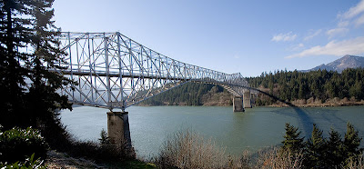
If you connect the north bank and south bank legs of your tour of the Columbia River Gorge with a crossing at the Bridge of the Gods, you're in for a surprise.

The Bridge of the Gods is a two-lane steel truss cantilever bridge that connects Washington State Highway 14 near Stevenson with Cascade Locks, Oregon. Built in 1926, the first thing you notice is there is a fifty cent toll for motorcycles.

What brings the real surprise is the deck of the bridge. It is a steel grate surface, and causes your vehicle wheels to travel an inch or two laterally as you drive or ride across. This can be an unnerving feeling especially for motorcyclists, but as long as you just relax and let the wheels travel you'll have no problem moving safely across.
Read more!

Sunday, June 7, 2009

Motorcycle the Columbia River Gorge

scenic-motorcycle-route

Looking to spend the day on a motorcycle ride out of Portland, Oregon? You won't find one more spectacular than riding along the Columbia River Gorge.

The Columbia River carved a canyon on its way through the Cascades, an area that enjoys protection as a National Scenic Area. A good way to motorcycle the gorge is to head out one side of the River and back on the other. Travel on the Washington side on Highway 14, a two-lane state highway with an average speed of 40-50 mph. On the Oregon side travel on Interstate 84 if time is short; otherwise don't miss the chance to ride the patchwork of remaining segments of the Historic Columbia River Highway, with an average speed of around 25 mph. Set the length of your ride by crossing the river at one of four bridges: Bridge of the Gods (40 miles from Portland), Hood River (60), the Dalles (80), or Biggs Junction/Maryhill (100). Read more!

Tuesday, May 5, 2009

Part 6 | Motorcycle to Alaska's Independence Mine

scenic motorcycle routescenic-motorcycle-route

A favorite Alaskan motorcycle day ride is the route from Anchorage to the historic Independence Mine. This is Part 6 of the Independence Mine Ride series.

Hatcher Pass Road, or Palmer Fishhook Road, crosses over the scenic Little Susitna River and winds up into the mountains towards Independence Mine. This paved road traverses the old mining route up into of the valley, and for about ten miles is one of the premier sections of motorcycle road curves and scenery anywhere.

Hatcher Pass Lodge is a good place to stop and let the motorcycle cool while you grab a bite to eat. From there you can explore the Alaska State Park's Independence Mine State Historical Park. At around 3000' elevation, you feel like you are on top of the world, and are high enough to see all the places you just motorcycled through: all the way to Palmer, the Butte, Eklutna, Eagle River and Anchorage.

The adventurous can take their motorcycle on up the gravel road through Hatcher Pass to Willow, and back to Anchorage via the Parks Highway. This route will add a couple hours, but is a worthwhile loop for those looking for more scenery, more wildlife, and a different ride back to Anchorage.

Read more!

Friday, May 1, 2009

Part 5 | Motorcycle to Alaska's Independence Mine

scenic-motorcycle-routescenic-motorcycle-route

A favorite Alaskan motorcycle day ride is the route from Anchorage to the historic Independence Mine. This is Part 5 of the Independence Mine Ride series. scenic-motorcycle-route

After crossing the Knik River, the Old Palmer Highway meanders through the Bodenburg Butte area, named for the solitary glacially-carved hill standing in the otherwise flat flood plain of the Matanuska and Knik Rivers. The Highway pulls alongside the Matanuska River until crossing it into the city of Palmer, home of the Alaska State Fair and it's world-famous enormous produce.

Taking a right turn onto the Glenn Highway, our motorcycle trip now follows the north bank of the Matanuska River until turning away on Farm Loop Road. As it passes through (you guessed it) more farms, this road becomes Palmer Fishhook Road and then Hatcher Pass Road. Finally we are heading into the mountains towards Hatcher Pass.


Check back to Motodometer later for Part 6 of this post.
Read more!

Wednesday, April 22, 2009

Part 4 | Motorcycle to Alaska's Independence Mine

scenic-motorcycle-roadscenic-motorcycle-route

A favorite Alaskan motorcycle day ride is the route from Anchorage to the historic Independence Mine. This is Part 4 of the Independence Mine Ride series.

After your motorcycle adventure to Eklutna Lake, a couple miles of travel on the Glenn Highway is unavoidable. The good news is the turn to Palmer via the Old Glenn Highway is only a few miles down the road! Take this route for a more leisurely and scenic road trip through the Matanuska Valley. The Old Glenn Highway is cut along the foot of the Chugach mountains, and follows the Knik River until crossing it on a new span that recently replaced the old open-girder bridge. If you choose not to turn and cross the river, you will be treated to another top-shelf 20 mile side trip.

This side trip is the Knik River Road, which continues on along the river for another 10 miles or so of paved motorcycle goodness. The pavement ends at another bridge, over a Knik River tributary, and turns to gravel for a few more miles of fun for the more adventurous motorcyclist. The rest of us turn around and ride the 10 miles back, turning right when we meet the Old Glenn Highway and crossing the bridge over the Knik River there.

Check back to Motodometer later for Part 5 of this post.
Read more!

Tuesday, April 21, 2009

Part 3 | Motorcycle to Alaska's Independence Mine

scenic-motorcycle-routescenic-motorcycle-route

A favorite Alaskan motorcycle day ride is the route from Anchorage to the historic Independence Mine. This is Part 3 of the Independence Mine Ride series.

About 25 miles from Anchorage is the exit for Eklutna Lake Road. This recently paved route clings to the edge of Eklutna River valley, and takes numerous slow curves and twists as it makes its way to Eklutna Lake. At the end of the road you'll find the Eklutna Lake Campground, hiking trails and the glacier-fed lake from which Anchorage draws its drinking water.

This is a must-ride motorcycle side trip. The lake is only about 10 miles from the Glenn Highway, but plan about an hour for the round trip with a quick stop at the lake.

Check back to Motodometer later for Part 4 of this post.
Read more!

Sunday, April 19, 2009

Part 2 | Motorcycle to Alaska's Independence Mine

scenic-motorcycle-routescenic-motorcycle-route

A favorite Alaskan motorcycle day ride is the route from Anchorage to the historic Independence Mine. This is Part 2 of the Independence Mine Ride series.

A few miles after you leave Anchorage on the Glenn Highway, take the Hiland road exit, right on Eagle River Loop then right on Eagle River Road. This route winds through some scenic motorcycling along the Eagle River Valley for 14 miles, until it terminates at the Eagle River Nature Center . Photo credit Laura Hillary. Take time to explore the nature trails or view salmon in the river from the observation deck. Remember, if you see a bear, slowly, quietly back away careful not to crack a twig or make the faintest sound and then run like hell!

On your way back towards the town of Eagle River, take a right on Eagle River Loop Road and a right on Old Glenn Highway. This route will avoid the interstate-like Glenn Highway as long as possible, and increase your enjoyment of the ride to Independence Mine. Total side trip distance = 28 miles and a bit less than an hour on the motorcycle.

Check back to Motodometer later for Part 3 of this post.
Read more!

Saturday, April 18, 2009

Part 1 | Motorcycle to Alaska's Independence Mine

scenic-motorcycle-routescenic-motorcycle-route

A favorite Alaskan motorcycle day ride is the route from Anchorage to the historic Independence Mine. This is Part 1 of the Independence Mine Ride series.

The historic Independence Mine is less than two hours away from Anchorage. That's IF you take the highway as much as possible. Sure you can save some time motorcycling straight there and back, but this post will detail the scenic route, slower roads less traveled with less traffic, along stretches of old highway, back roads around farms, and finally winding up the valley along the Little Susitna River until you reach the Independence Mine State Historical Park. Once there, a good restaurant awaits as well as tours and exploring among the buildings of the old mining town, far above the Matanuska-Sustina valley near Hatcher's Pass.

Check back to Motodometer later for Part 2 of this post.
Read more!

Thursday, April 16, 2009

Motorcycle commute: Pros and Cons

scenic-motorcycling-ridescenic-motorcycle-route

On the motorcycle your senses are much more closely in tune to the world around you. You might say riding the motorcycle is one way to get back in touch with nature. One major difference between riding to work in my car and riding to work on the motorcycle is the invigorating flow of air. On the motorcycle you are bombarded with the smells of whatever area you are riding through, and they cannot be avoided. Whether I am touring through a forest of douglas fir or motorcycling past a freshly-cut hay field, your nose tells you exactly where you are. On the down side, my commute to work every day takes me past one place I'd just as soon not be in tune with: An enormous dairy farm...! Read more!

Tuesday, April 14, 2009

Motorcycle to Whittier? Caution: Rough road

scenic-motorcycle-roadscenic-motorcycle-route

If you are thinking about motorcycling the spur road to Whittier off of the Seward Highway, (see post entitled Part 3 | Alaska's Seward Highway), you might want to wait a week or so.... A massive rock slide covered the road on Saturday 4/11/09, and still hasn't been cleared as of 4/14/09. It could take several more days to open. Read more about the rock slide here.

Read more!

Sunday, April 12, 2009

Part 7 | Motorcycle Riding Alaska's Seward Highway - National Scenic Byway

scenic-motorcycling-routescenic-motorcycle-route

My favorite motorcycle road of all time is from Anchorage to Seward on Alaska's Seward Highway. This is Part 7 of the Seward Highway series. The end of the aptly named Seward Highway is the All-American city of Seward, just a few miles past Exit Glacier Road. Check out the Seward Chamber of Commerce website, especially if you plan to spend a couple days exploring the area. Good seafood and a spectacular setting make this city memorable. If riding is your only mission, motorcycling the entire Seward Highway from Anchorage to Seward takes about two hours. Whether your ride takes two hours or two weeks, you won't forget your scenic tour down Alaska's Seward highway.

Read more!

Friday, April 10, 2009

Part 6 | Motorcycle Riding Alaska's Seward Highway - National Scenic Byway

scenic-motorcycle-roadscenic-motorcycle-route

My favorite motorcycle road of all time is from Anchorage to Seward on Alaska's Seward Highway. This is Part 6 of the Seward Highway series. scenic-motorcycle-tour-routeSoon after Tern Lake the road winds along the shore of Upper and Lower Trail Lakes, and past the Trail Lake Fish Hatchery. Numerous campgrounds and hiking trails are available along this stretch of the route, some along scenic Kenai Lake. The lakes in this area look a surreal blue/green, due to the influence of melting glaciers. A narrow canyon funnels the road from Kenai Lake down towards Resurrection Bay and the turn off towards Exit Glacier, another must-see side trip. The road to Exit Glacier a seventeen-mile round trip mixed bag, some gravel but smooth and paved for the last few miles. The dirt travel is totally worth it, as the road brings you within a few hundred yards of spectacular 10,000-year-old ice.

Check back later to Motodometer for Part 7 of this post.

Read more!

Thursday, April 9, 2009

Part 5 | Motorcycle Riding Alaska's Seward Highway - National Scenic Byway

scenic-motorcycle-roadscenic-motorcycle-route

My favorite motorcycle road of all time is from Anchorage to Seward on Alaska's Seward Highway. This is Part 5 of the Seward Highway series. scenic-alaska-motorcycling-roadOnce back on the Seward Highway after your side trip to Hope, the motorcycle rider is treated to a twisting climb up Canyon Creek gorge to the Summit Lakes. On the shore of scenic Upper Summit Lake, Summit Lake Lodge is a highly recommended place for lunch. Motorcycling past the Devil's Pass Trailhead, the road travels back down to Tern Lake, a wildlife viewing area and junction with the Sterling Highway.

Check back later to Motodometer for Part 6 of this post.

Read more!